
The Silent Valley Trails
Silent Valley Trails
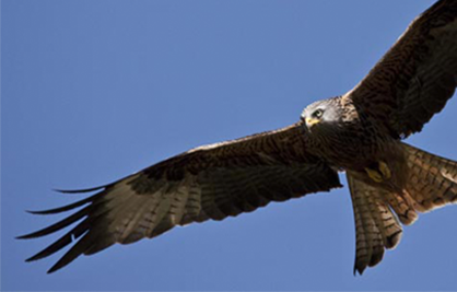
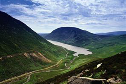
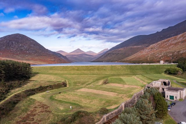
Enjoy the tranquillity of Silent Valley Mountain Park in the heart of the Mourne Mountains. Follow a trail to submerge in the beauty of the park. Find out about the industrial heritage which gave rise to the magnificent dams and shaped the surrounding landscape.
8/11/2023- Update on Temporary Closure of Trails
We have now been able to reopen the trail down to the boardwalk so all trails on the east side
of the river are now open again. We are working to carry out repairs to the trails on the set
side of the river, and will provide an update in due course. Again we appeal to visitors to
adhere to the signage and barriers for their safety, and we apologies for any inconvenience this
may cause
Trails have been graded according to difficulty:
Easy to complete, do not
require special foot wear and accessible for all.
Mainly on paths, some of which are gravel
and include steep steps.
Includes rough terrain and steeper
gradients.
NI Water would like to ackowledge its partners in this project.


Address
Silent Valley Mountain Park, Head Road, Kilkeel, Newry,
BT34 4HU
How to Get There
Vehicle access is possible only through the main
gates located on Head Road. A charge is payable at the entrance, currently £5.00 per
car. Drivers are required to obey the one-way traffic system which leads to a single
large car-park at the south end of the reservoir grounds.
Admission Charges
Car £5.00
Coach £35
Minibus £13
Motor
Cycle £2.50
Adults/Cyclists £1.60
Annual Pass £20
Annual Pass
If you visit Silent Valley on a regular basis you may
benefit from a Silent Valley Annual Pass. The current price is £20 for a car pass
and £50 for a minibus pass (up to 16 passengers) which will allow entry during
normal opening hours for one year.
Nature Trail
Distance: 1.8km (1.1 mile)
Route Description: Follow the Kilkeel River and former railway line used to transport men and machinery between the Silent Valley and Annalong. View the wildlife, such as dragonflies and damselflies and enjoy the lowland heathland under the boarded walkway.
Difficulty level one
Ben Crom Dam Walk
Distance: 10km (6 miles) - return
Route description: This linear route follows the tarmac road from Silent Valley to Ben Crom Reservoir and passes the exit of the Binian Tunnel (9), which was built (1949 – 1958) to carry water from the Annalong River to Silent Valley. Teams worked from either end of the tunnel and when they met in the middle, they were only 5cm apart!
Difficulty level one
Heritage Trail
Distance: 2.4km (1.5 miles)
Route description: Circular route including views over the dam into the mountains. Find out more about Silent Valley at the Interpretive Centre (3), which was the site of the original Police Station. Interest points Public Art Piece – “The Mourne Hand” (1) incorporates the story of stone, water and the resilient, skilled men of Mourne who built the dam with “hands like shovels”. Memorial (2) Commemorating the men who tragically lost their lives in the construction of the reservoirs.
Difficulty level two
Reservoir Trail
Distance: 1.7km (1 mile) - return
Route description: This trail highlights the engineering hub of the dam and gives a taste of the high Mournes with a backdrop of the Mourne Wall (Built 1904– 1922) which defines the boundary of NI Water’s catchment area, stretching over 22 miles and 17 peaks.
Interest points: Model of ‘cut off trenches’ (4) Trenches had to be built into the earth to prevent water seepage from under the dam. Filter Plant (5) This facility was used to screen raw water, a process that is now carried out by the Drumaroad Water Treatment Works. Boat House (6) Water overflow from the dam is directed under the dam wall to the Boat House where it joins the Kilkeel River. Overflow (7) A massive plug hole, 25 m deep, prevents the dam from flowing over. Valve Tower (8) This controls the out flow of water from the dam.
Difficulty level two
Mountain Trail
Distance: 3.4km (2 miles)
Route description: Enjoy the stunning scenery along this trail which incorporates steep climbs through typical Mourne upland habitat and woodland trails. Look out for the site of Watertown Site (12) and the Pugmill (13).
Difficulty level three
Challenge Trail
Distance: 3km (1.8 miles)
Route description: This scenic trail passes through some steep upland habitat and park woodland.
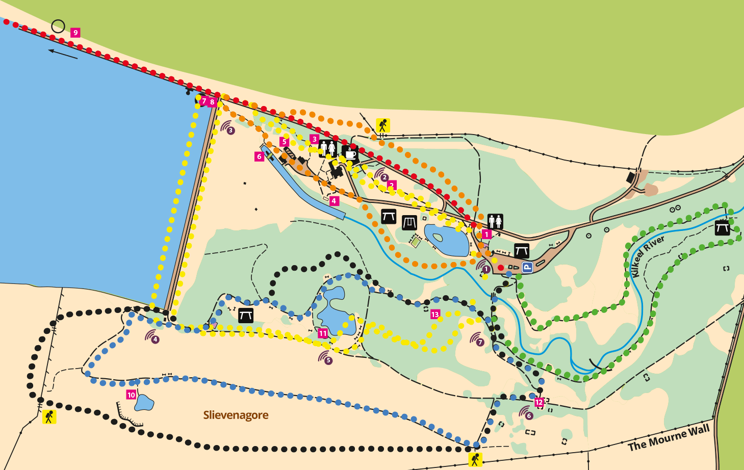
Interest points: Quarry Viewpoint (10) Cornish workers came here to prospect for silver and lead. Their singing and laughter may be the reason why the Silent Valley was formerly known as ‘Happy Valley’. A great place to see the heather bloom or glimpse birdlife such as ravens, wheatears, skylarks and if you’re lucky, peregrine falcons. Rest at the Shelter Seats (11) by Sally Lough which replicate those used by the stone cutters to protect them from the bitter wind and rain. Watertown Site (12) A temporary village known as ‘Watertown’ was constructed to house the 2000 strong workforce. At its peak it had a shop, cinema, hospital and dance hall as well as the first street lights in the island of Ireland. Pugmill (13) Clay was ground up here to remove stones to ensure it was watertight to build the dam embankment wall.
Difficulty level three
Gallery
Podcasts
English
- Podcast Point 1 Download MP3 - 2,294kb
- Podcast Point 2 Download MP3 - 2,089kb
- Podcast Point 3 Download MP3 - 5,434kb
- Podcast Point 4 Download MP3 - 2,142kb
- Podcast Point 5 Download MP3 - 1,244kb
- Podcast Point 6 Download MP3 - 1,865kb
- Podcast Point 7 Download MP3 - 5,434kb
Irish
- Podcast Point 1 Download MP3 - 2,582kb
- Podcast Point 2 Download MP3 - 2,261kb
- Podcast Point 3 Download MP3 - 5,661kb
- Podcast Point 4 Download MP3 - 1,933kb
- Podcast Point 5 Download MP3 - 1,208kb
- Podcast Point 6 Download MP3 - 1,983kb
- Podcast Point 7 Download MP3 - 1,563kb